
August 30, 2013
Bracing for the Rain
Here's what the forecast looks like for tonight, although some thunderstorms have already started pounding the area. Naturally, we're curious about how long they will last. We're also curious what kind of runoff there will be from the new construction. It's 5:50 PM.


August 7, 2013
August Construction Continues On the House That Will Add To Future Flooding
After the basement had been dug out, there was a huge pile of dirt in the front and the back of the house. The first two pictures are from the day after all that dirt was smoothed down by one of those pocket-sized, earth mover tractors.
The last two pictures are from a day or two after all the dirt had been leveled. A big shovel came in and dug a bunch of dirt up again to hook up the house pipes to the sewer lines. That may include the sump pumps as well as the catch basin or private drainage pipes. If anybody has a better handle on what those pipelines are for, feel free to 'splain.


July 29, 2013
The Village Answers Flood Map Questions
We sent a letter to the Village to ask about the accuracy of the flood maps first discussed in an earlier entry HERE.
Here's the response we received with answers from the ERA consultants in red. ERA is the company that does the maps and gives a thumbs up or down for improvements to our infrastructure. See if you think these replies sound like "We're the government and we're here to help." Or just more B.S. wrapped in jargon.
Dear [Village of Northbrook],
Oak Avenue Resident suggests: Get your butts out in the field.
Oak Avenue Resident suggests: Storm model? Really? Get your butts out in the field.
Oak Avenue Resident wonders: Huh?
Oak Avenue Resident asks: So the previous flood maps are wrong and you're going to correct them?
Oak Avenue Resident gets impatient: This seems to contradict your previous answer. Could you possibly write something that's jargon-free?
Here's the response we received with answers from the ERA consultants in red. ERA is the company that does the maps and gives a thumbs up or down for improvements to our infrastructure. See if you think these replies sound like "We're the government and we're here to help." Or just more B.S. wrapped in jargon.
Dear [Village of Northbrook],
The maps included in the H & H report show extensive street flooding on Westcott and Maple, where arguably NONE exists.
Where is the information for these maps coming from? The information for the surface elevations was obtained through the Village’s Geospatial Information System (GIS) which provides elevation information at one foot intervals. Contour mapping is generally considered accurate to within one half of the contour interval, so, in this case, vertical accuracy of the GIS should be plus or minus six inches. This area is relatively flat so there still may be some deviations in the field that are within the six inch tolerance. The storm sewer routing information was obtained from the Village’s utility atlas information.
There certainly wasn't flooding on Westcott or Maple during this last storm. While we were inundated on Oak. Far more than indicated on your map. And during the July 2010 storm, I had water up to my house from the street. As did several other homes. First, the storm model shows that the flooding in the area of Wescott and Maple occurs prior to the flooding in the 2400 block of Oak Avenue. It also subsides sooner. Therefore, it could have been that, once the flooding in the 2400 block of Oak Avenue was observed, the flooding at Wescott and Maple had already subsided.
The representastion of street flooding in the 2400 block of Oak Avenue should be well past the sidewalks on both sides of the street and more extensive from east to west. The limits of the extent of flooding may be somewhat different based upon the GIS one foot contour mapping.
Secondly, there is NO representation of the overwhelming backyard flooding we get on the 2400 block of Oak Avenue like there seems to be in the 2500 block. There is NOTHING ON THE MAP. Following the storm, we ran a computer model using the same information that was used for the information in the report, but updated to include hydrologic conditions observed during the recent storm. The output from this model depicts the backyard flooding in the 2400 block and seems to provide an good representation of the conditions that were reported during and after the recent storm event.
Oak Avenue Resident asks: So the previous flood maps are wrong and you're going to correct them?
We have proof with video and photographs. And I guarantee it's more than anything in the 2500 block, which is on higher ground.
Has there been a mistake? As discussed in the responses above, using the base information provided from the GIS system and utility atlases, when hydrologic information from the most recent storm is put into the computer modeling, it seems to provide a fairly accurate representation of the conditions reported. The model could be updated with more accurate topographic survey information but we don’t believe it would substantially change the results.
What proof do you have that there really is flooding in the backyards of the 2500 block of Oak on the north side? Or that there is actually street flooding on the 2500 block of Maple? We have seen none.
The backyard flooding shown on the map actually looks more like the 2400 block of Oak than the 2500 block. According to the GIS contour information, a significant amount of flow from the rear yards in the 2400 block of Oak Avenue runs onto Oak Avenue about three houses west of Western. If this flow area is restricted by obstructions in side yard ditches or swales it likely makes it more difficult for the water to drain out. These conditions could cause additional backyard flooding in the rear yards of the 2400 block than what is shown in the report. A detailed topographic survey of the side and rear yards in this area would be necessary to verify this condition.
Oak Avenue Resident suggests, once again: Get your butts out in the field.
And whaddya mean the "significant flow" occurs "about three houses west of Western?" It occurs in the backyards of the third, fourth, fifth, and sixth houses west of Western. But you wouldn't know that, because you don't get out in the field.
Even more egregious, to suggest that "obstructions" in the backyards on Oak Avenue are the reasons for the sudden enormous backyard flooding is another example of Village incompetence. As if the huge footprints and elevated grades allowed for the new construction on Maple Avenue had nothing to do with the oceans of displaced water that suddenly had nowhere to go, but down hill.
Can you explain how the alleged "obstructions" blocking the flow from the Oak Avenue yards occurred at the same time? To all those yards? Did we mention that the flooding was rIght after the mega-homes went up on Maple Avenue?
Oak Avenue Resident suggests, once again: Get your butts out in the field.
And whaddya mean the "significant flow" occurs "about three houses west of Western?" It occurs in the backyards of the third, fourth, fifth, and sixth houses west of Western. But you wouldn't know that, because you don't get out in the field.
Even more egregious, to suggest that "obstructions" in the backyards on Oak Avenue are the reasons for the sudden enormous backyard flooding is another example of Village incompetence. As if the huge footprints and elevated grades allowed for the new construction on Maple Avenue had nothing to do with the oceans of displaced water that suddenly had nowhere to go, but down hill.
Can you explain how the alleged "obstructions" blocking the flow from the Oak Avenue yards occurred at the same time? To all those yards? Did we mention that the flooding was rIght after the mega-homes went up on Maple Avenue?
But then, what more can we expect, when no one from the Village bothers to come out to the field?
Can you offer some way of proving that these maps are accurate, please? Hopefully, the explanations provided above are helpful in providing a better understanding of the accuracy and to some degree the limitations of the information shown on the maps.
Oak Avenue Resident replies to ERA Consultant: Short answer? No.
It's pretty clear none of the ERA people have been out to the 2400 block of Oak Avenue, EVER.
July 21, 2013
Anybody Know What This Is?
People seem reluctant to comment on this blog. But we have a question. You can be anonymous, when you answer. Or email us at oakavenueresident@gmail.com. Anyway, we took a picture of this U-shaped pipe thing by the fence of the new construction at 2429 Maple. What's it for? [UPDATE: We got close to the fence the next day and saw a tag that said it was a window well. There's even a ladder, so we're thinking it's a very deep window well.] Also notice the little sign with red type on the right -- NO TRESPASSING. Probably because we stand at the fence and shoot pix.


Some Feedback from The Flooding Survey
Ironically, a couple of weeks before the flood of June 26th, a neighborhood flooding questionnaire was left in the mailboxes of the twenty-one or so homes on the 2400 block of Oak Avenue. Wow, here's a chance for residents to express their frustration about the water problems, anonymously, if they chose. And only eight families took the time to reply.
Even more ironic was the number of homes with reclamation vehicles parked outside after the flood. The very homes that belonged to people who were too busy bailing water to fill out the survey, apparently.
Meanwhile, we promised to provide the results from the surveys we received. So here's a tidbit or two to give you an idea of what it's like to live in Water Land.
Straight from the survey, here are two comments about the history of flooding on the 2400 block of Oak:
The Village's solution is to expect the victims of the flooding to fix the problem themselves -- a problem the Village has caused by allowing the grade to be raised and permitting footprints that are too large [a quote from a Village engineer in 2008, by the way]. And those are just two of the usual suspects. The biggest problem is that the storm sewers can't handle the water that has no where else to go.
With every thunderstorm, Northbrook has demonstrated its clear and continuing failure to prepare ALL of its residential infrastructure for the future, which is HERE. This, despite decades of flooding throughout the Village.
Contractors continue to get building permits which allow them to build mega-houses on inadequate lots, without regard to the environmental effects they will have on the existing homes. And despite pleas to the VIllage from the surrounding homeowners.
Time will tell. What goes around comes around.
Even more ironic was the number of homes with reclamation vehicles parked outside after the flood. The very homes that belonged to people who were too busy bailing water to fill out the survey, apparently.
Meanwhile, we promised to provide the results from the surveys we received. So here's a tidbit or two to give you an idea of what it's like to live in Water Land.
Straight from the survey, here are two comments about the history of flooding on the 2400 block of Oak:
ii. Over 45 years I have lived on both the
North and South sides of the street and had flooding on both sides. We have
altered landscaping, put in a raised basement floor, a surface pump, and done
tiling from the backyard to the street with the Village’s permission.
Everything has helped, nothing has made for a completely dry basement in a
heavy flooding rain.
iii. We have lived
here for 16 years and have never had as many problems as the last few years,
which directly coincides with all of the new homes being built around us. We
are very disappointed in the Village of Northbrook for allowing such large
homes to be built on such small properties – eating away at all of the land –
land that used to drain water, but now the sewers are inundated. They don’t
care about all of the homeowners who have been here for years. All they care
about is building, building, building. Northbrook was going to work on our
sewers on our block, but are now re-evaluating because of cost. Well, we can’t
afford an overhead sewer system – and $5000 barely covers 1/3 of what it will
cost – not to mention the very intrusive way this system will be put in.
Northbrook should get their priorities straight.
Here is another owner's description of just his losses for ONE flood. And we've had three floods already this year. Multiply this by the number of homes we know for sure that were flooded on June 26th -- ten. Then multiply by the number of floods this year. Then multiply by the number of floods since the three one-hundred year floods of the 1980s.
7. List the
possessions you have lost to flooding along with their value:
i. Furnace = $2000
Water Heater = $1200
Washer/Dryer = $1200
Carpeting = $1800
Drywall = $300
Furniture = $3000
Toys = $1000
Electric = $3000
Sump Pump with back up = $600
[This was only one flood out of several
floods]
The Village's solution is to expect the victims of the flooding to fix the problem themselves -- a problem the Village has caused by allowing the grade to be raised and permitting footprints that are too large [a quote from a Village engineer in 2008, by the way]. And those are just two of the usual suspects. The biggest problem is that the storm sewers can't handle the water that has no where else to go.
With every thunderstorm, Northbrook has demonstrated its clear and continuing failure to prepare ALL of its residential infrastructure for the future, which is HERE. This, despite decades of flooding throughout the Village.
Contractors continue to get building permits which allow them to build mega-houses on inadequate lots, without regard to the environmental effects they will have on the existing homes. And despite pleas to the VIllage from the surrounding homeowners.
Time will tell. What goes around comes around.
July 18, 2013
We Follow the Progress of the New Construction
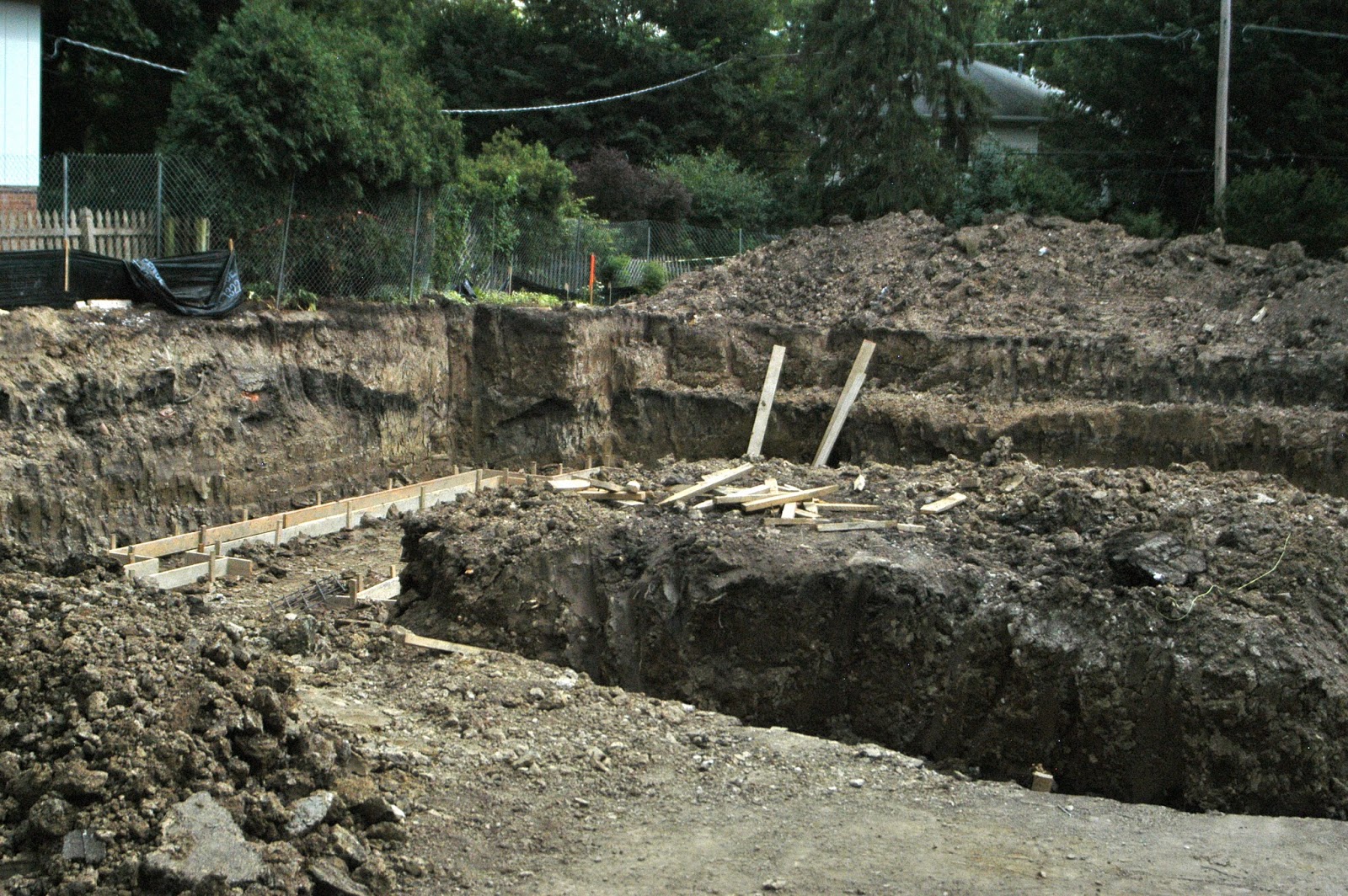
Here are some more pictures of the latest tear-it-down-build-it-bigger houses on the south side of the 2400 block of Maple Avenue. The pile of dirt is supposed to be used as "backfill" to quote someone we asked at the site. It won't be hauled away. Hmmm. Looks like enough dirt to raise the grade in back. It also looks like the plastic pipes for an in-ground sump pump are being laid. We were also told that there will be only ONE catch basin. "Because the sewers can't handle more." Duh. Wonder if there's anyway to tell whether the sump water will be pumped into the backyard or the Maple Street sewers. Inquiring minds want to know.




July 12, 2013
And the Walls Came Tumblin' Down!
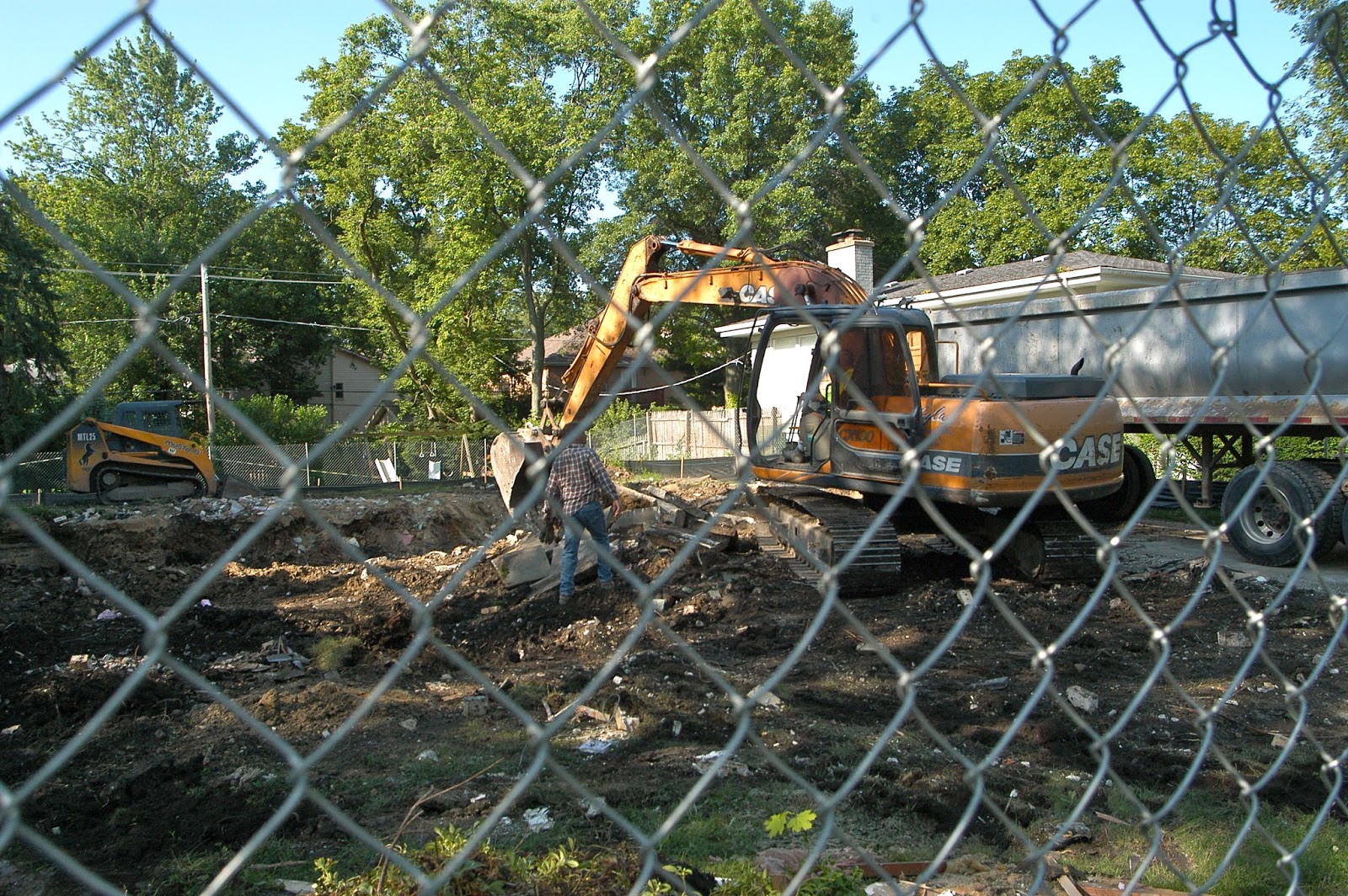
Meanwhile, we stopped by the morning after the tear down. The Tonka shovel was removing a lot of broken concrete. To our untrained eye, the hole seemed shallow, so we wondered whether the home had been built on a concrete slab with a crawl space instead of a basement. Will the new house have a traditional basement? If so, where will that extra dirt/water go?
We'll keep an eye out for signs of catch basins [don't expect more than one, since the sewer system isn't equipped to handle two.] There is a pile of excavation dirt in the upper right in some photos. It should be used for backfill. Will it?


Subscribe to:
Posts (Atom)